Some observations and thoughts, in no particular order:
- Welcome to Middle-earth.
- Was it worth it? It’s all about the journey, right?
- The next hike, San Francisco Bay Trail, will be dead flat.
- If you want to experience the first year of law school in a hike, try this one.
- Final numbers: 13.5 miles, almost 35,000 steps, 4600+ feet elevation gain – in short, a monster hike.
- If you want to thin out a hiking club, pick this hike. 25 or so hikers joined me last month for our 4-mile walk along the coast in Moss Beach. Yesterday, we had 3, and I saw fewer than 25 on the mountain, in the span of 7.5 hours.
- Start early, and do not hike this one alone. The Ohlone Wilderness, comprising almost 10,000 acres, is vast.
- We started at the Lichen Bark Picnic Area at Lake Del Valle, in Livermore, about 50 miles southeast of San Francisco. It took about 4 hours to hike up to Murietta Falls (2,992 feet), and 3 or so to return, factoring in lunch, at the waterfall.
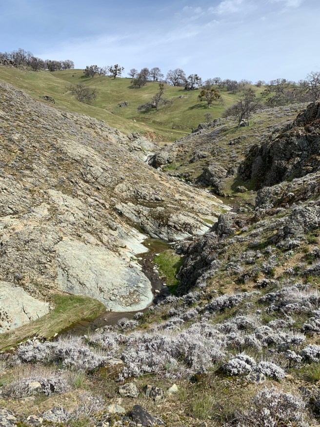
- Murietta is no Niagara. If you’ve seen one waterfall, you’ve seen (almost) all. Immediately below was my view of part of the falls, during lunch. You’ll see, perhaps, that it’s a series of falls. The trail, if you call it that, to the main waterfall is narrow and technical, and I turned back, as soon as it became clear that proceeding further risked falling into the waterfall.
- If you want solitude, this is it. But for a few hikers, frogs croaking, water gurgling, and occasional jet on its descent to SFO or OAK, there is silence. Enjoy your well-deserved lunch. Bring a book. Detox, from technology, etc. This is the place.
- “Is the top near,” I ask a hiker on her way down. She responds, “which top?” The Ohlone Wilderness keeps going and going. The top-top would be Rose Peak (3,817), just a hair lower than Diablo, another 3 or so miles southwest from Murietta Falls. Next time.
- I have lived in the San Francisco for more than 44 years, and have hiked many of its mountains and parks, include Mount Diablo, Mission Peak, Mount Tam, and so on. This is as vast and desolate a space as I have hiked. A perfect backdrop for a Bear Grylls adventure (although we did not have the benefit of an advanced scout team or chopper on demand), or name your favorite survival show. The Ohlone Wilderness Trail, in the span of 28 miles, links 4 regional parklands: Mission Peak, Sunol, Ohlone Wilderness, and Del Valle. Put otherwise, from Murietta Falls, we would have had to hike 21 or so miles to the other (western) end of the trail.
- You will need a permit for this hike. It’s $4 ($2 for the permit, and another $2 for shipping), and it expires a year from issuance. Go online and click a few buttons. Be sure to purchase the permit at least a week before you go. Also, it’s $6 to park.
- The Big Burn has nothing to do with California wildfires. Rather, it starts as soon as you traverse Willams Gulch (1890 feet) and continues, practically without interruption, to Schlieper Rock (3080 feet). I guarantee that you will quickly forget whatever is bothering you, at work, etc., within 5-10 minutes into this climb.
- The descent from Murietta Falls is not entirely a descent, with a relatively short uphill to Johnny’s Pond (below) and another, more significant ascent on the other side of Williams Gulch, to Rocky Ridge (2,426 feet). On that last ascent, I was reminded, by a fellow hiker, about the old adage, of simply putting one foot in front of the other.
- Relatively steep fire roads lead down to Lake Del Valle (750 feet), where our adventure ended, as it began, but with 13.5 miles under our hiking belts, enough elevation gain to take us most of the way up to Lake Tahoe, and probably a few battle scars. We enjoyed our obligatory Barebottle at a picnic table, reflected on the day, and vowed not to do this hike anytime soon. All kidding aside, our permits expire in a year, and I would not be surprised if we come back in the Fall, after the unforgiving summer heat. As intimated above, we have only scratched the surface.